
Introduction: Located immediately south and within 15 minutes of downtown Madison, the Capital Springs Recreation Area covers nearly 2,500 acres of Parkland. The area is jointly managed by Dane County and the DNR and is composed of several distinct units including: Lake Farm County Park, the Lake Waubesa Shoreline, the Lewis E-Way, The Lussier Family Heritage Center, Jenni and Kyle Preserve, the Nevin Fish Hatchery, the Monona Wetlands, the Madison Metropolitan Sewerage District Wildlife Observation Area, the Capital City State Trail and several municipal Parks managed by the cities of Fitchburg and Madison. With these many diverse resources the Area was officially designated as Capital Springs in 2000 and chosen as one of two Centennial State Parks. With its proximity to a large population center, the park and recreation area provides a large natural resource area for thousands people each year and its importance will continue to grow.

Natural Resources: Identified by Professor Phillip Lewis in the late 1960s as part of his visionary E-Way concept, the Capital Springs State Recreation Area can be described as a vast east/west oriented wetland complex with spring fed Nine Springs Creek traveling down the center. Gentle, rolling hills composed of ground moraine are located primarily to the north and south of this wetland complex providing for diverse plant and animal life. The hydrology of the recreation area is one of its most notable attributes, with a number of springs and associated recharge areas supplying a high quality flow to the Nine Springs Creek and on to Lake Waubesa. Over 1100 acres of wetlands retaining rainwater, buffering floods, recharging groundwater, and filtering runoff are protected by this Park.
High quality, rare, or significant natural communities present within the recreation area include southern sedge meadow, shrub-carr and a shallow hard drainage lake emergent aquatic community. Two rare, plant species—white lady’s slipper and yellow giant hyssop have been documented. The most common wildlife species seen throughout the recreation area are deer, turkey, sandhill cranes, hawks, pheasant, fox, and a variety of waterfowl. The Area also includes Upper Mud Lake with an abundance of pan fish.
High quality, rare, or significant natural communities present within the recreation area include southern sedge meadow, shrub-carr and a shallow hard drainage lake emergent aquatic community. Two rare, plant species—white lady’s slipper and yellow giant hyssop have been documented. The most common wildlife species seen throughout the recreation area are deer, turkey, sandhill cranes, hawks, pheasant, fox, and a variety of waterfowl. The Area also includes Upper Mud Lake with an abundance of pan fish.

Cultural Resources: Many historic sites have been identified in the Capital Springs Recreation Area. The greatest concentration of archaeological resources is found within the Lake Farm County Park Unit and the areas along the shore of Lake Waubesa. Artifacts discovered included several dating back to the Early Archaic and Late Woodland periods. Intensive study of the area identified 32 prehistoric sites in Lake Farm Park alone and led to its designation as a location on the National Register of Historic Places. The area along Lake Waubesa was very attractive to native peoples including the Ho Chunk Nation due to an abundance of fish, shellfish, wild game, nuts, and berries making settlement particularly attractive. As a result of this long history of settlement, E-Way and Capital Springs are a treasure of human history. Several other Indian Mounds have been discovered in other areas of the Park. Information suggests that Ho Chunk people lived along the lake as late as the 1930's.
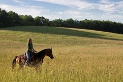
Recreational Resources: As its name implies, the Area has a wealth of active and less intense recreational options including, bicycling, walking and hiking along the Capital City State Trail and the E-Way trails. Birding opportunities abound including the Observation Area near the lagoons at Madison Metropolitan Sewerage Complex. Many songbirds such as bobolinks, Henslowe's sparrow, grasshopper sparrow, savanna sparrow, and sedge wren have been seen. Recent additions include a dog exercise area and a first class disc golf course. Nine Springs Creek, the Yahara River, and Lake Waubesa provide watercraft access to the Recreation Area. Through the hard work and dedication of the Friends group and County staff, new hiking and canoeing trails are available in several areas of the Park providing views of the Lake, wetlands, and connecting park amenities to neighborhoods. A special area for meditation is the Jenni and Kyle preserve, designed particularly for people with physical challenges.
Bicycle access to the recreation area is special due to its central location. Trails link to a number of regional bicycle trail systems, including the Military Ridge, Badger, and Glacial Drumlin State Trails and making the recreation area a hub for the region. A number of spur trails and bridges have been cleared by the Friends of Capital Springs and Dane County to improve pedestrian and bicycle connectivity to adjacent residential areas. To be completed by 2017, a new bridge and trestle will use an existing railroad grade to cross Lake Waubesa and provide bicycle/pedestrian access to the Village of McFarland and beyond. Additionally, Upper Mud Lake is one of the most popular spots for fishing year-round in Southern Wisconsin.
Units of The Recreation Area Include:
The Lewis E-Way: The Capital Springs Recreation Area follows the land identified by the visionary Professor Phillip Lewis. The E-Way, is a unique Environmental corridor with land and water resources, It provides a wonderful Ecological and cultural mixture at Lake Farm Park and a venue for Education and Exercise. The E-Way gives us a place to reflect and enjoy the Esthetic natural beauty around us..
The Jenni and Kyle Preserve: Located on Post Road, it is special place within the recreation area, designed to be used by people who have physical and mental challenges. The mural erected there is beautiful.
The Nevin Fish Hatchery: Located near the west end of the Park and operated by DNR, this historic building is still functioning as a regional fish hatchery growing many of Wisconsin's game and recreational fish.
Lake Farm County Park: The signature park in the Recreation Area covering 380 acres of archeologically significant land and Lakeshore as well as the Lussier Heritage Center. The Park provides diverse recreational opportunities.
Capital Springs State Shoreline: The beautiful area immediately south of Lake Farm Park provides views of beautiful Lake Waubesa, hiking trails along the shore and out to Hogg Island, a special peninsula jutting out into the Lake.
MMSD Wildlife Observation Unit: Located in the North part of the Area, the unit provides unique opportunities for wildlife observation and is a destination for birding year-round.
Disc Golf and Dog Exercise Area: Developed by the County, and located in the southern part of the Area, these amenities are popular destinations for many.
Capital City State Trail: Traversing the Recreation Area, the trail is one of the main arteries in the park providing bicycling trails connecting to many other local and regional trails.

Friends of Capital Springs and Partnerships: Friends of Capital Springs is essential to coordinate the work in the park and management of its natural resources.
Capital Springs is managed by several units of government including Dane County, the Wisconsin Department of Natural Resources, the Madison Metropolitan Sewerage District, the Cities of Fitchburg and Madison. Shared ownership provides opportunities and challenges. The Recreation Area Management Agreement formally vests the role of coordinating and planning for the Recreation Area in the Friends. The Friends provide the consistent vision and coordination as well and the ability to leverage financial resources. Moreover, the Friends have been the focus for engaging the community in this unique resource. In addition to fund raising, the Friends developed partnerships with MMSD and other municipalities, conducted significant invasive removal and stewardship of the land and water, sponsored community outreach activities, facilitated educational tours, water quality monitoring and cultural events.
Capital Springs is managed by several units of government including Dane County, the Wisconsin Department of Natural Resources, the Madison Metropolitan Sewerage District, the Cities of Fitchburg and Madison. Shared ownership provides opportunities and challenges. The Recreation Area Management Agreement formally vests the role of coordinating and planning for the Recreation Area in the Friends. The Friends provide the consistent vision and coordination as well and the ability to leverage financial resources. Moreover, the Friends have been the focus for engaging the community in this unique resource. In addition to fund raising, the Friends developed partnerships with MMSD and other municipalities, conducted significant invasive removal and stewardship of the land and water, sponsored community outreach activities, facilitated educational tours, water quality monitoring and cultural events.


 RSS Feed